The old geographical maps show the peculiarities of the making of a nation, the singularity of world perception and originality of peoples at different stages of their history; the maps created on the territory of modern Ukraine in olden times influenced many other sides of human history.
The first primitive cartographic images in primitive society reproduced the people’s view of their locality. The Ukrainian lands were depicted on small-scale old Greek and Roman maps, works of Christian and Islamic cartographers, and portolanos. The later development of Ukrainian land mapping was due to the spread of Ptolemaic maps in Europe, instrumental works of G. Beauplan, products of Austria-Hungary and Russian military topographers, and initiation of thematic mapping.
The simplest cartographic images ('pre-maps' or 'prehistoric maps') were known in the primitive society before the invention of written language. They supplied information on a locality: hunting and fishing places, nomadic routes, plans of plots, etc. These first cartographic drawings were created on various materials: bark, leaves and wood, skin and bones of animals, stone etc.
In Ukraine they have found a dozen cartographic images of early times. The best known is the drawing on the fragment of mammoth tusk found in 1966 during excavations under I.H. Pidoplichko on the Rosava riverside near the village of Mezhyrich of Kaniv Raion, Cherkasy Oblast’, on the site of Paleolithic mammoth hunters. It shows the locality and brings out a river, vegetation (bushes, forest), and habitations. It is the oldest Ukrainian piece of cartography created approximately from 15 to 17ths years ago (fig. 1).
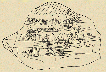
Fig. 1. The Mezhyrich map (approx. from 15 to 17 ths years ago). 2.4 times reduction
The oldest information about Ukrainian lands is in the works of Old Greek (Herodotus, Strabo) and Roman (Pliny the Elder, Tacitus) scientists. Claudius Ptolemy (c. 90 – c. 160 AD) systematized the geographical concepts of the time in his eight-volume work (Guide to Geography).
One of the oldest cartographic images of the territory of Ukraine is the so-called Tabula Peutingeriana (Peutinger table), an itinerarium showing the cursus publicus, the road network in the Roman Empire of the 4th c. In olden times there were also maps containing circumnavigation descriptions. The Arabic cartographers of 12th c. represented the Ukrainian lands as well. Later sailing aids or portolanos showed the Black and Azov seas (from the late 13th to 16th c.).
In 15th c. the invention of engraving and printing, import and spread of Geography by C. Ptolemy in Europe greatly influenced the development of cartography. For the first time the Ukrainian lands appeared in print in 1477 in Bologna edition of Ptolemy’s Geography on the Tenth map of European Sarmatia at a scale of approx. 1:5 700 000 (fig. 2). It was a copperplate with several additions of N. Hermann.
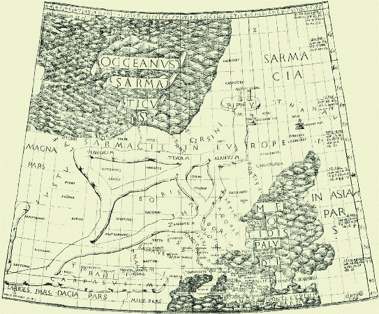
Fig. 2. The first presentation of Ukrainian lands on the Tenth map of European Sarmatia in Ptolemy’s Geography (Bologna, 1477). 3.1 times reduction
From 16th c. the image of Ukrainian lands in European editions became more precise. At the time the maps of Ukraine were made by foreign cartographers and published in numerous Geographies and later Cosmographies of G. Mercator and A. Ortelius. The M.-K. Radziwill Map of the Great Duchy of Lithuania (approximate scale 1:1 300 000; 1613) was of the greatest importance for the development of mapping of Ukraine in 17th c.
The first printed domestic maps began appearing in 17th c. The first one was the drawn plan of Kyiv in the Teraturgima lubo cuda by Athanasiy Kalnofoiski (Anastasy Kondoidi, Ukrainian author writing in Polish) published by the order of Petro Mohyla in the Kyiv Cave Monastery in 1638. The book contained three perspective drawings of Kyiv (fig. 3) showing Pechers’k district with plans of the near and far caves.
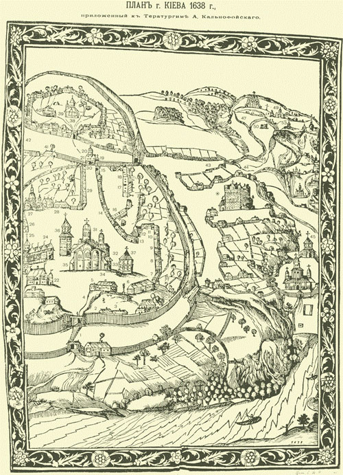
Fig. 3. Drawn plan of Kyiv in the book of A. Kalnofoiski Teraturgima (Kyiv, 1638). 1.5 times reduction
In the second half of 17th c. there emerged plans of private property, villages and towns, delimitations of plots of land. The mapmaking flourished here and there; for the sake of military fortification the cartographers created maps of built-up areas, fortresses and castles. Later the maps of townships were needed for the city economy bookkeeping and for registration of owners. From 17th to 19th c. they began using the plans of townships not only for fortification, but also for city planning, economic and fiscal needs.
The new stage of mapping of Ukrainian territory was opened by the new survey methods. The first innovator was French military engineer, architect and cartographer Guillaume Le Vasseur de Beauplan (1600–1675) who authored the famous Description of Ukraine … (1651). His creation of the maps of Ukraine on the basis of his own survey data should be regarded as his major merit. His chief cartographic work The Special and Detailed Plan of Ukraine Together With Its Provinces and Raions (this Special map of Ukraine at a scale of approx. 1:450 000) contains eight 41.5x45 cm sheets; it was engraved and printed by V. Hondius in Gdansk in 1650 (fig. 4). It is the first medium-scale military topographical map of the large territory in Europe, on which, except for the rivers, roads, forests and mountains, many built-up areas are shown (26 symbolic representations).
Fig. 4. The special map of Ukraine of G. Beauplan, section V (Gdansk, 1650). 3.3 times reduction
In the 17th c. and first half of the 18th c. the Beauplan’s map was widely used in European cartography for representation of Ukrainian lands. G. Beauplan made the greatest contribution to the development of map drawing in Ukraine in 17th c. His maps based on fundamental survey data were the most trustworthy in Europe concerning the representation of the territory of Ukraine. Due to his cartographic works and their numerous recompositions the name Ukraine was put into use.
From the end of 18th c. military cartography riveted special attention. Now triangulation came into use for topographical surveys. The long-term programs of topographical survey of the territory of Ukraine were carried out by Austrian and Russian military topographic services.
From 1797 all national cartographic jobs in the Russian Empire were carried out by the Depot of Maps. The Ukrainian lands were shown on the Detailed Map of the Russian Empire and the Adjacent Foreign Possessions (the so-called Stoarkusheva Karta) published at a scale of 1:840 000 in 1801–1804. In 1816 Major General Mukhin headed the compilation of the 10 sheet (63x45 cm) Military Topographic Map of the Crimean Peninsula at a scale of 1:168 000.
From 1822 the Military Topographers Corps carried out the state topographical surveys and personnel training on the permanent basis. This Corps under General K.I. Tenner and Academician V.Ya. Struve carried out the outstanding task of grade measuring of the Russian-Scandinavian arc of meridian from the Arctic Ocean down to the mouth of the Danube 25''20' long.
In 1821–1839 the 59-sheet Special Map of the Western Part of Russian Empire (ten-versta issue) was edited and published at a scale of 1:420 000. In 1845 they started the compilation of the Military Topographic Map of Russia at a scale of 1:126 000 (known as three-versta edition). By 1873 775 nomenclature sheets of this map were prepared for publication (fig. 5). Military cartographer I.P. Strelbyts’kyi (1828–1900) from Poltava Province and his team used this three-versta military topographic map to prepare 152 sheets from 1865 to 1871 and publish several sheets of the Special Map of European Russia at a scale of 1:420 000 in 1871; they covered Ukrainian lands ruled by Russian and Austrian Hungarian empires. The west of the Central Ukraine was shown on the Military Topographic Map at a scale of 1:84 000. In 1914 it was published as the Secret Map of the Western Borderland on 200 sheets (Volyn’, Kyiv, Podillia, and Mins’k provinces).
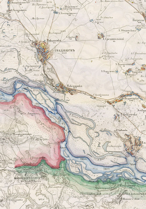
Fig. 5. The fragments of three-versta Military Topographic Map of Russia (1870)
The first survey of Halychyna with the use of triangulation was performed under Austrian cartographer Josef Liesganig (1719–1799) at a scale of 1:72 000 in 1773–1774. The map at a scale of 1:288 000 was published on 49 sheets (31.3x23.4 cm) in Vienna in 1790.
In Austria, from 1763 to 1785, the Austrian Quartermaster General’s Department carried out the first survey for military purposes (Josef’s mapping). The Josef’s Map of the Crown Lands of Galicia and Lodomeria of F. von Mig at a scale of 1:28 000 consists of 413 sheets (42x62 cm).
In 1806 the second territorial survey of Austrian empire was initiated (Francis’ survey), which lasted until 1869. The survey was conducted by the Austrian Quartermaster General’s Department for the needs of military; from 1839 the Military Geographical Institute in Vienna, opened the same year, carried on the job. On the basis of survey tablets at a scale of 1:28 800 the Topographical Map of the Austrian Monarchy (known as the old special map) including all national territory at a scale of 1:144 000 was published in 1810–1879.
In 1869–1887 the Military Geographical Institute used the updated triangulation network for Austria–Hungary to carry out the third military topographic survey (Francis–Josef). The survey data at a scale of 1:25 000 were used to compile and publish the New Special Map of Austria-Hungary and Occupied Areas at a scale of 1:75 000 in 1873–1889 (fig. 6). Ukraine occupied by Austria-Hungary was shown on 88 sheets. Later they kept reprinting it for some time.
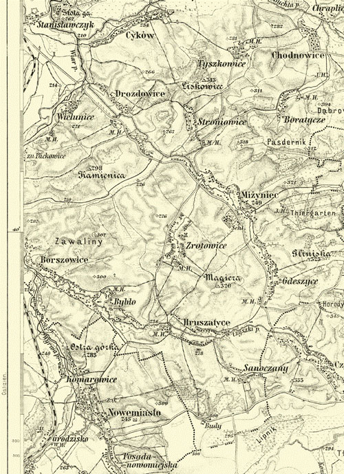
Fig. 6. The fragment of the New Special Map of Austria-Hungary and Occupied Areas to the scale 1:75 000 (Vienna, 1873–1889)
In 19th c., with the development and differentiation of geographical, natural and socio-economic sciences, there emerges the thematic cartography (geological, climatic, demographic, ethnographic, industrial, agricultural, transport etc.). The development of productive forces and necessities of raw materials supply brought about geological survey and geological mapping. The thematic mapping of Ukrainian lands was carried out by state departments and scientific establishments of Russia and Austria-Hungary employing Ukrainian, Russian, Polish, and Austrian scientists.
In 1882 the Geological Committee of Russian Empire began making the 170-sheet General Geological Map of European Russia at a scale of 1:420 000. However, only seven of 16 sheets covering Ukraine were ready by 1917 and only three of them were published. In 1892 the detailed geological survey of the Donets’k Coal basin was initiated. On the basis of one-versta survey data under L.I. Lutugin (1864–1915) the Detailed geological map of Donets’k coal basin at a scale of 1:42 000 was created; it allowed for the first time to calculate coal reserves of Donets’k Basin. The edition of Geological Atlas of Halychyna at a scale of 1:75 000 became an event in geological mapping of West Ukrainian lands. The atlas was published in quires containing text and tables. By the beginning of WWI in 1914 25 quires including 101 sheets were given out.
From the mid-19th c. the thematic maps of nature began to appear: hypsometric (O.A. Tillo), climatic (K. S. Veselovskii, O.I. Voieikov, G.I. Vil’d, O.A. Tillo, O.V. Klosovskii), soils (K.S. Veselovskii, V.V. Dokuchaiev), forests (P.M. Verekha, M.K. Genko).
Considerable attention was paid to the maps of rivers. We will but mention the handwritten Atlas of Dnipro River including the general map of Dnipro at a scale of 1:840 000 and 95 double sheets of Dnipro streambed at a scale of 1:8 400. In the second half of 19th c. many maps and atlases were made in Ukraine on the basis of surveys and explorations of navigable rivers.
From the end of 18th c. the postal maps began emerging; they showed roads, post stations and distances between the stations. The Military Geographical Institute published road maps covering Halychyna and Bukovyna. At the end of 18th c. the first toponymic maps of Halychyna and Bukovyna were created.
Russia published many socio-economic maps and atlases showing Ukraine (Atlas of Economy and Statistic of European Russia (1851); Statistical Atlas of Main Branches of Industry of European Russia (three editions: 1869, 1870, 1873); transport economic atlas Influence of Railroads on Russian Economy (1876); Map of Trades and Industries in European Russia at a scale of 1:1 680 000 (1911); and atlas Agribusiness in Russia (1914) etc.).
There was the breakthrough of sugar industry mapping in Ukraine in the second half of the 19th c. At the same time the mapping of population evolved.
The Ukrainian national revival brought about ethnographic researches and the creation of ethnographic maps. The first Ukrainian ethnic maps were published in Lviv in the 60s of 19th c. Hryhory Velychko (1863–1932), first Ukrainian doctor of geography published his map The Population of Ukrainian-Ruthenian people at a scale of 1:1 680 000 in 1896.
Linguist Kost’ Mykhalchuk (1840–1914) published his Map of Southern Rus Tongue (61x77 cm); it was based on the ethnographic and linguistic researches of the South-West Department of Russian Geographical Society conducted in 1871; it became a major step in the development of Ukrainian linguistics and Ukrainian linguistic cartography (fig. 7). For the first time the domestic scientists used their own data creating the linguistic map of Ukraine and showing the limits of the settling of Ukrainians.
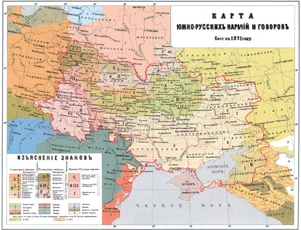
Fig. 7. The Map of Southern Rus Tongue of K.P. Mykhalchuk (Saint Petersburg, 1872). 5.8 times reduction
The historical maps of the territory of Ukraine began appearing in the second half of 19th c. as additions or text maps in the works of Ukrainian historians. The pioneer in this field was professor of L’viv University Isydor Sharanevych (1829–1901); he published a number of text maps. The historical maps as illustrations for popular editions were made by V. Ilnyts’kyi, I. Krevets’kyi, O. Barvins’kyi, B. Barvins’kyi. Ukrainian historians V.B. Antonovych, M.M. Arkas, D.I. Bahalii, M.S. Grushevs’kyi, M.V. Zakrevs’kyi, A.O. Skalkovs’kyi, D.I. Yavornyts’kyi etc. included historical and archaeological maps as addenda into their works.
The development of educational cartography determined the general status of cartography in Russia and Austria-Hungary and state of studies. From the second half of 18th to the first half of 19th c. the educational atlases were rather reference sources and failed to meet the standards of courses in geography and history.
The first Ukrainian cartography primers were published in Lviv due to public organizations. The first Ukrainian educational atlas was The Geographical Atlas of Professor Myron Korduba (1912, 1917, 1928). The twenty-four-page atlas included 24 basic maps and 11 additional dealing with the world geography.
In the early 20s c. S.L. Rudnyts’kyi (1877–1937) entered the scene of Ukrainian training cartography. He substantiated the method of creation and edition of geographical maps and principles of development of school demonstration maps. In 1907 the first Ukrainian map of the world was published: The Map of Western and Eastern Hemispheres. In 1918 the Wall Physical Map of Ukraine at a scale of 1:1 000 000 was brought out; the publication was sponsored by the Shevchenko Scientific Society (fig. 8). The map covers the entire ethnic territory of Ukraine and contains five thematic insert maps at a scale of 1:5 000 000. During 1919–1920 S.L. Rudnitsky published in Vienna educational wall maps, both physical maps of the world and continents.
In February 1918, in Kyiv, the one-sheet School Map of Ukraine at a scale of 1:1 680 000 was published under the scientific editorship of P. Tutkovsky.
The occasional editions from the second half of 19th c. of Ukrainian thematic and educational maps laid grounds for the Ukrainian national cartography.
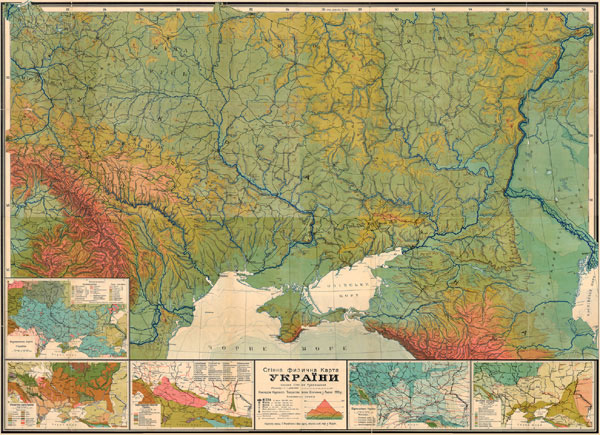
Fig. 8. The Wall Physical Map of Ukraine by S.Rrudnytsky to the scale 1:1 000 000 (Vienna, 1918). 14.5 times reduction

